About Horizon 2050
The Horizon 2050 LRTP is a 25-year plan that will guide transportation system decision-making for the GPATS study area and will provide a list of transportation projects that meet future transportation needs in the region. GPATS conducts a small review and update of the LRTP every five years and a major update every 10 years. The transportation system includes:
- Highways
- Streets
- Transit
- Freight
- Sidewalks and walking trails
- Bike trails and lanes
MPO 101
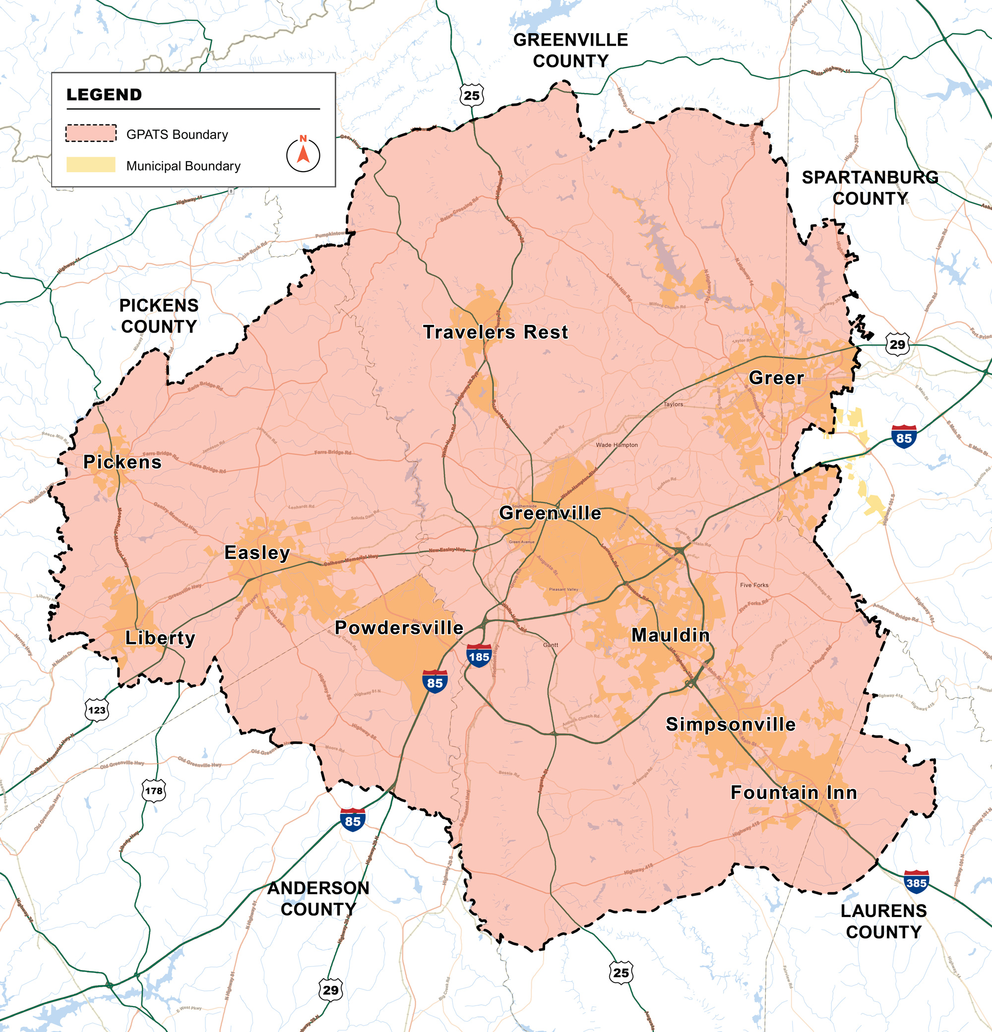
Federal law requires that any urbanized area with a population of over 50,000 people have a Metropolitan Planning Organization (MPO) that carries out multimodal transportation planning (like an LRTP). GPATS is the official MPO that serves as the formal transportation planning body for the Greenville-Pickens metropolitan planning area.
The GPATS became an MPO in the fall of 1964 and was originally called the Greenville Area Transportation Study (GRATS). In April 2004, following the 2000 Census results, the GRATS planning area was expanded to reflect the updated census-designated urbanized area. This expansion extended the study area into Pickens County and the incorporated municipalities of Pickens, Liberty, and Easley, prompting GRATS to become the Greenville-Pickens Area Transportation Study (GPATS).
After the 2010 Census, the Greenville urbanized area expanded again, adding the municipalities of Central, Clemson, Norris, Pelzer, Pendleton, West Pelzer, and Williamston, which were incorporated into GPATS in March 2013.
Following the 2020 Census, GPATS was required to adjust its boundaries to reflect new changes to the region’s urbanized areas. The urbanized area decreased in size, particularly in Anderson and Pickens Counties. The MPO lost the cities of Norris, Central, Clemson, Pendleton, Williamston, Pelzer, and West Pelzer. These municipalities were added to the Anderson-Clemson Area Transportation Study (ACATS) MPO, previously known as the Anderson Area Transportation Study (ANATS).
-
1964
GRATS established -
2004
Expansion from GRATS to GPATS with the addition of Pickens, Liberty, and Easley -
2013
Addition of Central, Clemson, Norris, Pelzer, Pendleton, West Pelzer, and Williamston -
2023
Boundary adjustment resulting in the loss of Norris, Central, Clemson, Pendleton, Williamston, Pelzer, and West Pelzer
Study Area
Status Update
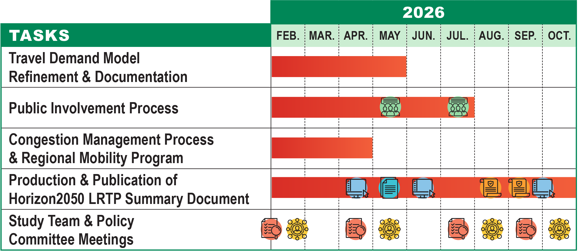
- Travel Demand Model Refinement and Documentation - February to May 2026
- Public Involvement Process - February to July 2026. Community meetings in May and July
- Congestion Management Process and Regional Mobility Program - February to April 2026
- Production and Publication of Horizon2050 Long Range Transportation Plan Summary Document - February to October 2026.
- Existing Condition Report in May 2026.
- Draft and Final Long Range Transportation Plan Document in August and September 2026. Website and web portal updates in April, June and September.
- Study Team Meetings in February, April, July and September 2026
- Policy Committee Meetings in February, May, August and October 2026
Public engagement for the Horizon 2050 LRTP Update is underway! We will visit six cities between May 11 and May 21 to gather in-person feedback on local transportation needs and priorities. Visit the Get Involved page for more information on public meeting times, dates, and locations, or to access the transportation survey!!